Central Viet Nam braces for wet weather as LPA formed in East Sea, likely developed into tropical depression
Meteorologists at Viet Nam’s National Centre for Hydro-Meteorological Forecasting (NCHMF) are tracking a low pressure area (LPA) in the East Sea that is responsible for rain and thunderstorms during daytime and night hours on Monday in Central Viet Nam, including Da Nang, Central Highlands and Southern Viet Nam, with heavy to very heavy rainfall at isolated locations.
 |
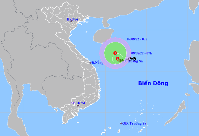
| The forecast track of the newly-formed LPA over the East Sea. (Source: NCHMF) |
The National Weather Service predicts that moderate to heavy rainfall are likely to lash over Mid-central region and Central Highlands on Monday with extremely heavy rain likely in some places. The total rainfall amount will be 50mm-80mm in common in the region while more than 100mm of rain could fall in some places.
As much as 20mm-40mm of rain could fall over North Central Coast, the Southern Central Region and Southern region, even more than 60 mm in some places.
The forecaster has warned that there will be showers and thundery downpours in Central Viet Nam, including Da Nang, Central Highlands and Southern Viet Nam during daytime and night hours on Tuesday. Localized rainfall accumulations could reach 20 to 40mm, and localized accumulations in excess of 60mm are possible tomorrow, August 9.
There are also warnings of thunderstorms, lightning strikes, high winds, tornadoes and hail in these areas.
Forecasters have issued warnings of flash floods and landslides for mountainous areas in these areas, including Da Nang, and localized flooding alerts are in place in low-lying and riverside areas. The advisory urges residents to ‘be aware’ of inclement weather. Local residents are advised to get ready for such weather conditions in an attempt to reduce the risk of possible damages.
In its latest bulletin, the National Weather Service said that at 1:00am on Monday, the LPA was already located at latitude 15°8'N-16°8'N and longitude 111°5'E- 112°5'E, sitting over the waters of Hoang Sa Islands.
Over the next 24 hours, the system will move northwestward in the East Sea at 5mph, and it will continue to gain strength, and is likely to develop into a tropical depression.
At 1:00am on Tuesday, August 9, the system’s center will be positioned at latitude 17°N and longitude 111°4'E, will lie to the Northwest of Hoang Sa Islands. The maximum sustained winds reaching level 6 (39-49mph), and the gusts as high as level 8 will affect areas near the potential depression’s center.
An advisory for strong winds, rough seas and high waves is issued in the next 24 hours to all vessels operating in the potentially dangerous area which is located at latitude 15°5'N - 18°5'N and longitude 110° E - 112°5'E.
Under these conditions, the offshore areas stretching from Binh Dinh to Ca Mau, the East Sea (including the waters of the Truong Sa and Hoang Sa Islands) will see gradually increasing winds at levels 5 to 6, and the gusts reaching level 8, and experience rough seas with waves as high as 2-4m.
In addition, the LPA is bringing the threat of showers and thunderstorms to the offshore areas stretching from Quang Tri to Ca Mau, including Da Nang, Ca Mau to Kien Giang, the Gulf of Thailand, the East Sea (including the waters of the Truong Sa and Hoang Sa Islands), national weather forecasters have warned.
The Da Nang Steering Committee for Disaster Response and Search and Rescue is urging authorities at local level and relevant units to take mitigation measures in response to severe weather conditions.
The Da Nang Border Guard Command is asked to work with Da Nang Coastal Information Station to keep a close watch on disturbance developmen in the East Sea in order to keep owners of vessels operating at sea timely informed about severe weather conditions to help them take the initiative to avoid dangerous areas or seek safe shelters during the bad weather.
Special attention must be given to making the resources available in order to organize timely rescue of any person in distress at sea and provide timely support for those who need it during severe weather.
The authorities at local level must take resilience measures to help save lives and reduce the damage to individual houses, public infrastructure and crops. In addition, all necessary steps are needed to move people living in low-lying areas, along rivers and streams and areas at high risk of flash floods and landslides to safe places. Special attention must be given to making the resources available in order to drain rainwater from agricultural fields, low-lying areas, urban areas, most densely populated areas, industrial zones and other areas most at-risk of flooding in an effort to reduce costly damage to crops and property.
Reporting by baotintuc- HOANG HIEP – translating by H.L


