Rains continue to lash Da Nang as depression in East Sea strengthens into storm Mulan
The tropical depression in the East Sea on Tuesday afternoon intensified into a tropical storm, and it was given the international name Mulan, according to the Mid-Central Region Centre for Hydro-meteorological Forecasting.
Mulan is the second storm to enter the East Sea so far this year.
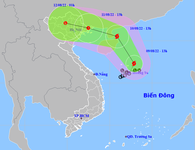 |
| The expected track of Mulan (Source: The National Centre for Hydro-Meteorological Forecasting) |
In its latest bulletin, the Regional Weather Service said at 1:00pm on Tuesday, the storm’s center was already located near latitude17°3'N and longitude 112°9'E, it lied to the northeast of the Hoang Sa (Paracel) Islands, about 300km Southeast of China’s Hainan Island. The radius of strong winds at level 6 and gustiness of level 8 was about 110km from the storm’s center.
Over the next 24 hours, the storm will move northwards in the East Sea, then it is expected to move in a northwesterly direction at 15-20kmph, and it has greater potential to become a stronger storm.
At 1:00pm on Wednesday, August 10, the storm’s center will be positioned near latitude 20°5'N and longitude 110°9'E, lie to the east of China’s Leizhou Peninsula, and about 350km southeast of Quang Ninh Province’s Mong Cai City with the maximum sustained winds reaching level 8, and gustiness of level 10.
The storm is set to move toward west- northwest at about 5kmph, and and it is likely weaken into a tropical depression after hitting the northeast of the Northern Viet Nam.
Due to the influence of storm Mulan, the Northern part of the East Sea and waters around the Hoang Sa islands will see strong winds at levels 6 to 7 while the area near the storm’s center will experience high winds at level 8, and gustiness of level 9 with rough seas and waves as high as 4m to 6m.
Under these conditions, the Gulf of Tonkin (including Co To and Bach Long Vi islands) will see strong winds at levels 6 to 7 while the area near the storm’s center will experience high winds at level 8, and gustiness of level 10 with rough seas and waves as high as 2m to 4m during evening and night hours on Wednesday.
The offshore area stretching from Binh Dinh to Ca Mau, the middle and south of the East Sea (including the waters of the Truong Sa Islands), will see gradually increasing winds at levels 6 to 7, and the gusts reaching level 9, and experience rough seas with waves as high as 2-4m due to the combined effects of the storm and the southwest monsoon.
Most parts from Quang Binh to Thua Thien Hue will continue to experience rains with moderate to heavy rainfall and thunderstorms likely in isolated places. Meanwhile, rainfall is expected to continue in few places over the parts from Da Nang to Quang Ngai during daytime while some places will receive moderate rainfall and thunderstorms during night hours.
A warning for showers and thunderstorms has been issued for the offshore area stretching from Quang Binh to Quang Ngai, including Da Nang. The norther part of this area will see west to northwest winds while the southern part will experience west to southwest winds at levels 4 to 5, and gustiness of levels 6 to 7. Thunderstorms can produce tornadoes, lightning, hail and strong winds, regional forecasters has warned.
Reporting by HOANG HIEP – Translating by H.L