Level 4 weather warning issued for Da Nang, Quang Nam, Quang Ngai, Binh Dinh as typhoon Noru expected to hit these localities early Wednesday morning
Viet Nam’s National Centre for Hydro-Meteorological Forecasting (NCHMF) continues to monitor typhoon Noru that moved into the East Sea early Monday morning.
Noru is the fourth storm to enter the East Sea so far this year, and it will threat the Mid-Central region.
NCHMF has issued its highest weather warning alert at level 4 for Da Nang, Quang Nam, Quang Ngai, Binh Dinh as the hurricane is expected to make landfall over these localities early Wednesday morning, September 28. Noru is expected to be a powerful hurricane-force cyclone as it will hit these localities with wind gusts predicted at levels 9 to 10. The maximum sustained winds reaching levels 11 to 12, and the gusts as high as levels at 14 to 15 will affect areas near the storm’s center. Farther inland could see maximum sustained winds at levels 8 to 9, and gustiness of levels at 12 to 13.
 |
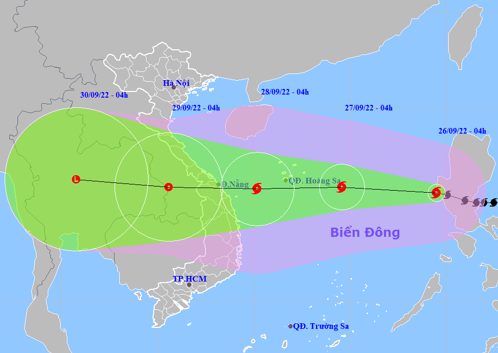
| Map and projected Noru path (Source: NCHMF). |
Forecast models indicate at 4:00am on Monday, September 26, the storm’s center sat over the waters off the western coast of Luzon Island, Philippines, about 810km east of the Hoang Sa (Paracel). The storm’s center experienced maximum sustained winds reaching levels at 12 to 13, and the gusts as high as level 14.
Over the next 24 hours, the storm will move generally west- northwestward at 20-25km per hour. At 4:00am on Tuesday, September 27, Noru was will be centred near latitude 15°9' N and longitude 114°6'E, about 250km southeast of the Hoang Sa Archipelago, packing maximum sustained winds at level 13, and and gustiness of level 16.
Over the next 24 hours, the danger area in the East Sea around the tropical storm which is located at latitude 12°5' N - 20°N and longitude 111°5' E, could see strong winds at level 6 or higher, and the gusts as high as level 8 or higher. Warning for strong winds, and big waves has been issued for all vessels operating in the danger area.
Noru is expected to grow stronger as it tracks the west at 20-25km per hour. At 4:00 am on Wednesday, September 28, the storm’s center will be positioned near latitude 15°8' N and longitude 110°2' E, about 170km east of the mainland of the parts from Da Nang to Binh Dinh, with maximum sustained winds reaching levels at 13 to 14, and the gusts as high as level 17.
Noru will continue its track westward at 20-25km per hour and it gradually weaken into a tropical depression after making landfall over the Mid-central region early Wednesday morning.
Due to the influence of typhoon Noru, the Northern part and the middle of the East Sea will see thunderstorms and strong winds at levels 8 to 9, then increase to levels 10 to 11 while the area near the storm’s center will experience high winds at levels 12 to 14, and gustiness of level 17 with rough seas and waves as high as 8m to 10m.
From Tuesday noon, September 27, the offshore areas stretching from Quang Binh to Ninh Thuan (including Con Co, Cham, and Ly Son islands) could see strong winds at levels 8 to 9, then increase to levels 10 to 11 while the area near the storm’s center will experience high winds at levels 12 to 14, and gustiness of level 17 with rough seas and waves as high as 8m to 10m.
From Tuesday evening, September 27, the coastal areas from Thua Thien Hue to Binh Dinh will see rough seas and waves as high as 3-5m, and 6-8m seen in the area near the storm’s center.
A storm surge warning has been issued for the parts from Quang Tri to Quang Ngai with 1-1.5m surge alert, that could cause flooding in low-lying areas near ocean and estuaries. An advisory for strong winds, big waves, tornadoes and storm surge has been also issued for all vessels and marine farms operating in these areas.
From Wednesday morning, September 28, the coastal areas from Quang Tri to Ninh Thuan, including Da Nang, will see high winds at level 6, then increase to levels 7 to 8, and the gusts as high as levels at 9 to 10 while the coastal areas from Da Nang, Quang Nam, Quang Ngai and Binh Dinh will experience strong winds at levels 9 to 10. The maximum sustained winds reaching levels 11 to 12, and the gusts as high as levels at 14 to 15 will affect areas near the storm’s center. Farther inland could see maximum sustained winds at levels 8 to 9, and and gustiness of levels at 12 to 13.
On Wednesday, September 28, Kon Tum and Gia Lai could see high winds at level 6, then increase to levels 7 to 8, with the possibility of strong winds at level 9 and gustiness of level 11 at isolated places.
From Tuesday afternoon into Wednesday, the best chances for heavy to very heavy rainfall, thunderstorms and wind gusts will be in the Mid- Central region, the Norther part of Central Highlands. The total rainfall amount will be 150-300mm in common in these areas while more than 350mm of rain could fall in some places. From Wednesday into Friday, rain activity will expand northward to North Central Coast.
Reporting by HOANG HIEP – Translating by H.L


