Da Nang top leader asked for concerted efforts in response to typhoon Noru
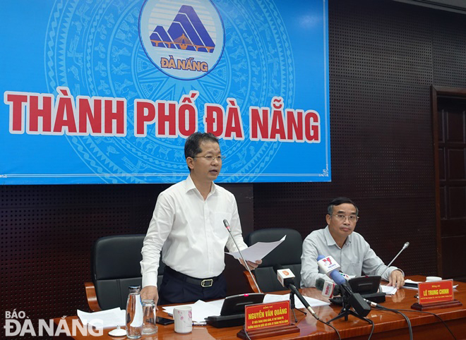
An urgent meeting to discuss mitigation measures in response to typhoon Noru, chaired by Da Nang Party Committee Secretary Nguyen Van Quang and municipal People's Committee Chairman Le Trung Chinh took place in the city on Monday morning.
 |
| Da Nang Party Committee Secretary Nguyen Van Quang (right) and municipal Peoples Committee Chairman Le Trung Chinh chaired an urgent meeting on Tuesday to discuss mitigation measures in response to typhoon Noru. Photo: Hoang Hiep |
Mr Quang stated that typhoon Noru has the potential to become the strongest storms known to make landfall and hit Da Nang over the past 20 years, thereby calling for all necessary measures to protect the safety of local residents and their properties during the extreme weather event in an effort to prevent the loss of life and minimize the damage to property from the storm.
Focus must be must keeping a close watch on severe weather development, and keep local residents timely informed about severe weather conditions in order to help them protect their property from the hurricane. In addition, the heed must be paid on assisting local residents to prepare for the storm in an attempt to reduce the risk of possible damages. Local residents are advised to stay indoors until the storm is over in order to minimize the loss of life. In addition, all necessary measures are needed to move people living in areas prone to flooding landslides to safe places.
Mr Quang remarked that police and military personnel will be core force to support the city’s efforts in the rescue and evacuation of local people. Importance should be attached to making the resources available in order to organize timely rescue of any person in distress at sea and provide timely support for those who need it during severe weather.
The Da Nang Party Chief stressed the need for authorities at local level and relevant agencies to complete the evacuation of people in areas prone to flooding and landslides before 2:00pm on Tuesday while securing sufficient supply of foods and medical products for people in evacuation shelters and those in potential areas that are isolated and inaccessible due to the flood waters and landslides.
Mr Luong Nguyen Minh Triet, the Deputy Secretary of the municipal Party Committee, Chairman of the municipal People's Council called for effective implementation of the city’s plan for the prevention, control and mitigation of the consequences of the storm. He also asked for active coordination between authorities at local level and military units to conduct cleanup and recovery efforts following typhoon Noru.
In its latest bulletin, Viet Nam’s National Center for Hydro-meteorological Forecasting (NCHMF) said that at 10:00am on Monday, September 26, typhoon Noru was already centred near latitude 16°N and longitude 118°1'E, sat over the Northern part and the middle of the East Sea, about 650km east of Hoang Sa Islands, packing maximum sustained winds at level 12, and and gustiness of level 14. The radius of strong winds at level 10 and gustiness of level 12 was about 100km from the storm’s center.
Over the next 24 hours, Noru will continue to gain strength as it moves generally westward at 20-25 km per hour. At 10:00am on Tuesday, the storm’s centre will be positioned near latitude 15°7'N and longitude 113°2'E, lie over southeast of Hoang Sa Islands, with maximum sustained winds at level 13, and the gusts as high as level 16.
The storm will further intensify as it continues its track towards west at at 20-25 km per hour. At 10:00 am on Wednesday, September 28, the storm’s centre will be located near latitude 15°6'N and longitude 108°5'E, right on the mainland of the parts from Thua Thien- Hue to Quang Ngai, including Da Nang, packing maximum sustained winds at level 12, and and gustiness of level 14.
Due to the influence of typhoon Noru, the Northern part and the middle of the East Sea will see thunderstorms and strong winds at levels 8 to 9, then increase to levels 10 to 11 while the area near the storm’s center will experience high winds at levels 12 to 14, and gustiness of level 16 with rough seas and waves as high as 9m to 11m.
From Tuesday noon, September 27, the offshore areas stretching from Quang Binh to Ninh Thuan (including Con Co, Cham, and Ly Son islands) could see strong winds at levels 8 to 9, then increase to levels 10 to 11 while the area near the storm’s center will experience high winds at levels 12 to 14, and gustiness of level 16 with rough seas and waves as high as 8m to 10m.
From Tuesday evening, September 27, the coastal areas from Thua Thien Hue to Binh Dinh will see rough seas and waves as high as 3-5m, and 6-8m seen in the area near the storm’s center.
A storm surge warning has been issued for the parts from Quang Tri to Quang Ngai with 1–1.5-m surge alert, that could cause flooding in low-lying areas near ocean and estuaries. An advisory for strong winds, big waves, tornadoes and storm surge has been also issued for all vessels and marine farms operating in these areas.
Reporting by HOANG HIEP – Translating by H.L


